ClarionCall.Com

Search ClarionCall.com


The people's choice in Livingston County... and beyond!
You Are Here:
Home»Genesee Country»Our Coverage Map
Go To:
Lake and Valley Clarion NewspaperGenesee Country MagazineClarion Communications

Open the Door to . . .

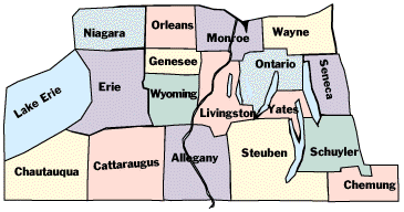
Genesee Country Map
What is the Genesee Country?

In the late 1700s, the first European settlers in western New York referred to The Genesee Country as including everything west of the so-called "pre-emption line." This north-south line started at Sodus on Lake Ontario and ran south through Seneca Lake and on to the Pennsylvania border. The dominant Native American tribe in the area were the Seneca Indians, who styled themselves as the "Keepers of the Western Door" of the Iroquois Confederation.

Over the years, many people forgot about the old definitions and began to think of the Genesee Country as solely the area adjacent to the Genesee River which starts in Gold, Pa. and runs north to Lake Ontario. The river cut the beautiful gorges of Letchworth State Park, "the Grand Canyon of the East", meanders across the broad lower Genesee Valley and powered the early mills of Rochester "the Flour City".

In 1993, with the debut of Genesee Country Magazine, "The Magazine of the Western Door" the concept of the Genesee Country began to grow again. While our first issue concentrated on the 10 counties bordering the Genesee Valley, reader interest soon encouraged us to expand our coverage to the 17 county area shown above.

For our editorial purposes, we define the Genesee Country today as most of the following counties: Allegany, Cattaraugus, Chautauqua, Chemung, Erie, Genesee, Livingston, Monroe, Niagara, Ontario, Orleans, Schuyler, Seneca, Steuben, Wayne, Wyoming and Yates. For tourism information about this region, see our online Western New York Travel Guide.

According to WebCounter you are the person to answer the Clarion Call
©2000 Clarion Publications, Inc. All Rights Reserved.
This site designed by Clarion Communications.